865.337.9346
865.337.9346
Geophysical surveys help protect the earth, environment, and humans by aiding in the reducing and removing the risk of Material Potentially Presenting an Explosive Hazard (MPPEH).
At HL Environmental we have qualified field staff ready to perform digital geophysical mapping (DGM) to locate unexploded ordnance (UXO) at sites across America and the rest of the world. We employ a range of techniques and processes to achieve the best possible detection capabilities in the shortest time frame.
HL staff has been very successful in achieving outstanding safety and environmental records. HL incorporates measures into our process to decrease the environmental impacts associated with disposal. Our field personnel consolidates MEC for disposal whenever possible to reduce the amount of donor explosives needed and the size of the footprint.
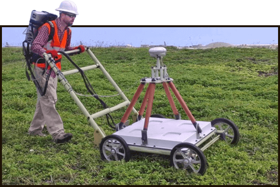
The towed array will consist of an EM61-MK2 on a sled or wheeled platform. The determination as to which method to be used for mapping will be established after analyzing the specific instrument’s detection capabilities at the GPO and/or after consideration of local site conditions.
HL processes and analyzes UXO data using Geosoft’s OasisMontaj software with the UX-Detect module. This software enables the application of data corrections to the raw data and generating corrected gridded data which is used to interpret anomaly locations.
Chief Marketing and Strategy Officer
865-337-9346 tcollins@hlenvironmental.comHuman Resource Manager
H&L Environmental Services, LLC
564 McArthur Rd., Maxton, NC 28364
Website:
HL Environment Services